
 Siege ramp from Crusader era still protects Ashkelon
HANNAH BROWN
While this ramp may have been built originally as part of a war, its remains have served a very different and peaceful purpose: preventing sand from drifting into the city.
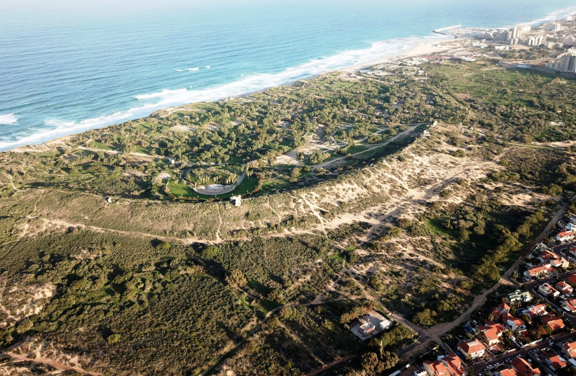
For Dr. Rafael Lewis, a lecturer at Ashkelon Academic College and a researcher at the University of Haifa, looking at aerial photographs and a landscape study of Ashkelon sparked an idea.
Lewis, who studies both landscape archaeology and battlefield archaeology, identified what he is convinced are the remains of a huge siege ramp that was likely constructed in the 12th or 13th century, during one of several sieges that the area went through during the Crusader era.
But while this ramp may have been built originally as part of a war, its remains have served a very different and peaceful purpose, preventing sand from drifting into the city.
“With landscape archaeology, we study landscape to understand how humans were influenced by landscape and how they changed it; it’s about the reciprocity between humans and landscape,” he said.
Using a landscape archaeological study conducted between 2010 and 2013, as well as aerial photographs from the 1940s, Lewis formulated his theory. He wrote about it extensively in his theory about the ramp and its later uses, in a chapter in the recently published book Crusading and Archaeology, published by Routledge Press.
The city was built in the Iron Age by the Canaanites with ramparts in the shape of the letter D or like a bow with the string running along the coast. It was conquered time and again as civilizations rose and fell, and each would use and sometimes rebuild the ramparts: Philistines, Romans, Byzantines and eventually Muslims and Crusaders.
In addition to the landscape archaeological study and the photographs, he examined written, archaeological and environmental sources which “revealed a fundamental difference between the area within the city’s rampart and to the north of it, on the one hand, and the area to the south, on the other. While the area south of the tel and to the middle of it northwards along the outer part of the rampart is seen covered by sand, the area in the tel itself and north of it is intensely cultivated, with clear evidence of agricultural activity and settlement,” Lewis wrote in the chapter.
The remains of the siege ramp continue to protect the area to its north from sand, he said, noting that this natural benefit is “the result of man-made features related to siege activities inflicted on the city in the 12th century, the siege which resulted in the conquest of Ascalon [Ashkelon] in 1153 by the forces of the Kingdom of Jerusalem, or alternatively the siege imposed by Salah ad-Din 34 years later, which ended with the city’s surrender on 4 September 1187.”
He wrote that he was convinced that the siege rampart built during one of those two sieges is the feature blocking the sand movement from south to north.
However, more research needs to be done to ascertain who built the ramparts.
“It is highly likely that archaeological digs in the area east of the Jerusalem Gate will teach us more about the siege system, and may even produce findings that can be linked to this historical event, one which still resonates and echoes” in the landscape of contemporary Ashkelon, he wrote.
Zawartość publikowanych artykułów i materiałów nie reprezentuje poglądów ani opinii Reunion’68,
ani też webmastera Blogu Reunion’68, chyba ze jest to wyraźnie zaznaczone.
Twoje uwagi, linki, własne artykuły lub wiadomości prześlij na adres:
webmaster@reunion68.com